Power with two AA batteries for up to 20 hours of use
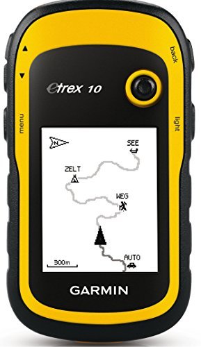
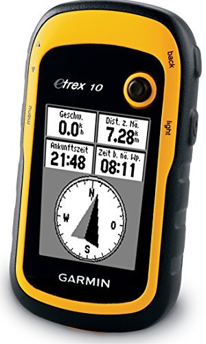
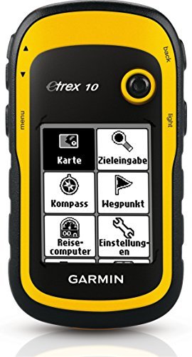
Edition:Base Model The eTrex 10 makes a great choice in handheld navigation for the budget savvy outdoor enthusiast. This eTrex model is equipped with a high-sensitivity GPS receiver, a 2.2-inch monochrome display, and a worldwide basemap making it easier than ever to see where you are and where you have been.
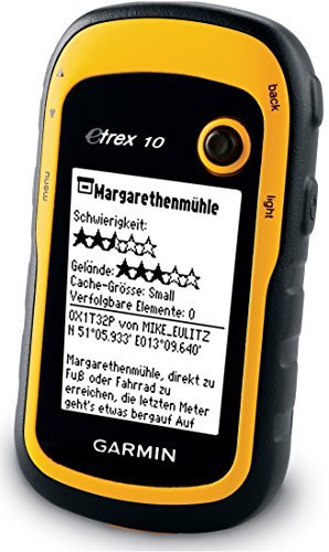
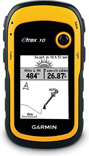
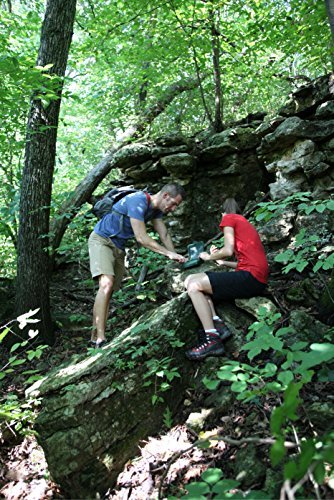
This device (the eTrex 10) is a gem. Thus the five star rating. I’ve been studying it and using it on bicycle rides for the past two months. I’ve read several of the Amazon reviews for this product, and few do a good job of informing the consumer. I think this is because the product caters to so many different endusers: boaters, kayakers, walkers, hikers, off-road cyclists, and on-road cyclists. My review is written from the perspective of an on-road cyclist. And I’m not going to write a review as much as merely answer a series of questions.1. Can you charge this device using a USB cable? >>No. The device uses two AA batteries for power. They can be cheap alkaline, or the more expensive rechargeable NiMH or lithium. Alkaline work ok if the weather is warm or hot. If you go the rechargeable route, don’t buy cheap ones that have less than 2000 capacity. I didn’t know rechargeables came in different capacities. Duh! The rechargeable batteries you need to recharge in a separate recharging device.2. What do you use the USB cable for that comes with the device? >>To connect your device to your PC or Mac so you can update software or move GPX files on or off the device. GPX files are what tracks and waypoints are stored in. I use a Web site called RidewithGPS to create my TCX files. Then I use other software to convert them to GPX files. Think GpsVisualizer dotcom.3. Can you load maps into this device? >>Not really. There is an almost nonexistent base map that comes with the unit. It is supposedly possible to overwrite it with a different map. However, for you to add maps to this device you would need to be able to insert an SD card which is where you would store extra maps. Since you cannot install an SD card into this device, you cannot add maps.4. Can you use this device on long bike rides so you don’t get lost? Is it good for bicycle touring? >>Yes. This is why I purchased this device.5. Can this device aid one in navigating a city walk? An outdoors hike? An off-road bicycle ride? An on-road bicycle ride? Yes to all four questions. I use the device for GPX files I create using a free online service called RidewithGPS dotcom. The GPX files are the end-product of designing a route. Some of the routes are through city streets. Some are through trails in the various outdoor parks near my home. Some are mountain bike trails. And some are 200k brevet rides on roads. I copy the GPX files into the GPX folder in my device and I’m ready to go.6. Can an SD card be installed into this device? >>No. Not on THIS device. Pay a little more to get the eTrex 20x or the eTrex 30x and you will be able to install an SD card in those devices.7. Is it easy to read this device in sunlight? At nighttime? >> Yes. Yes. I have found it easy in both daytime and nighttime. Of course, I have to wear glasses that correct my vision well. The viewing screen is somewhat small.8. Is this device good for long distance bike rides like brevets? >>Yes. GPS navigational devices designed for cyclists typically have internal rechargeable batteries that will die after 10 to 12 hours of constant use. Since the eTrex 10 uses two AA batteries, when they die they are easily replaced while riding the bike. As long as you have extra AA batteries along during your rides you will never be without a functioning eTrex 10.9. How long does it take to find satellites before it starts working? >>Depends. It always cranks up quickly (within a minute) for me. However, I have both kinds of satellites enabled in my system setup. Uses more power this way though.10. Is the user manual instructive? >>It is OK. The problem with the manual is the uses the device can be put to are so broad: boating, walking, hiking, biking off-road, and biking on-road. There really should be a manual for each type of user – and there just isn’t. Furthermore, do you want to use the device to mark geocaches? To merely be a navigation tool? Or to record where you have gone so you can retrace your steps? I’m really only interested in using the device as a navigation tool.11. Does this device track pace and distance traveled? Can it double as a bike speedometer? >>Yes. Yes. You can configure the view screen to tell you how far you have traveled at any point in time. And you can configure it to tell you how fast you are going in mph or kph.12. How relevant are street signs when using this device? >>Street signs are not really relevant because maps are not really relevant. With this device and your GPX file you will have a track (breadcrumb trail) and waypoints (usually along the trail). I create my GPX file so the names of the waypoints are street names. When the device is functioning a cursor shows up in the view screen indicating where I’m actually planted on the earth. As it moves along the track and I approach a waypoint I know it’ll be time to make a turn. I can make the turn without even knowing the name of the street. And when riding in the middle of the night I rarely look for street signs to verify a turn. Of course, it is nice to see a street sign that matches the waypoint title. Waypoint titles show up in my view screen as I ride.13. Does the view screen easily scratch? >>Yes. This is a problem. Invest in a $10 screen saver.14. Does this device provide turn-by-turn instruction when being used? >>No. You only get turn-by-turn instructions when a GPS device uses an installed map to “calculate” your route. This device doesn’t even have a map. But the eTrex 20x and eTrex 30x models do have maps. However, those units don’t use the maps to calculate routes. The maps are just background images to the tracks and waypoints that appear on the respective view screens. All three units allow you to create proximity warnings around your waypoints. And when you get within a certain proximity of a waypoint you can be warned. This function works kind of like turn-by-turn instructions. Unfortunately, I have found them not to be too helpful. They tend to clutter up my view screen.15. Can you insert a pre-loaded route? >>Yes. See answer to Q12.16. What kind of battery life can one expect? >>With two rechargeable NiMH AA batteries with capacity of 2600 each you’ll probably get more than 20 hours. This has been my experience while having both types of satellites accessed and leaving the backlight on constantly.17. Does this device have touchscreen features? >>No. If it did you wouldn’t get 20 hours of battery life. See answer to Q16.18. What memory does this unit have? >>Only internal. This device does not let you install SD cards. The eTrex 20x and eTrex 30x does allow for SD cards. Those units cost more.19. What kind of batteries does this device use? >>AA batteries. See answer to Q1.20. When the batteries die do you lose your current track and any waypoints? >>Nope. This is because information is saved as you go along, and the route is not “calculated” during your ride. The track is static information, as are the waypoints. When you turn the device back on after changing the batteries the cursor in your view screen shows your current location just like when the power went out.21. What file formats does this device read? >>Only GPX files, which are XML text files with a .gpx extension. Won’t read TCX or FIT file formats. To create GPX files I download my routes from Ridewithpgs and then use one of a few free online converting Web sites to convert the TCX file to a GPX format file.22. Does this device have an audio component? >>Nope. If it did, then you wouldn’t get 20 hours of battery life. However, pay a little more and get the eTrex 20x or eTrex 30x and you will have some audio capability. For example, the proximity alarm in the eTrex 10 will not produce any bells or beeps, but the other two units do.23. Does this device have a mapping function? >>It will record where you have gone if you want it to. Save the file when you are done, and you can upload it to RWGPS, Garmin Connect, Strava, or MapMyRide.
I bought the eTrex 30 as a long deserved upgrade from my eTrex Vista (which is still going strong) and have been very happy with it. It’s fairly small so it’s easy to bring along on any walk or hike, mount to a bike, hang on a backpack, etc., but still large enough to be useful in a car (using a dash mount). I have Topo maps loaded on a microSD card which really makes this unit great. I like to exploring using Forest Service roads and trails, and with this eTrex on my side I never feel like I don’t know where I am. The screen is clear enough and easy enough to see even in the sun even though it’s small. Battery life is really good. I use rechargeable batteries and after a full day of use they’re nowhere near being depleted. It’s loaded with features much like previous versions, but I really like the extra geocaching features. Overall a great compact GPS for hiking and more.
I purchased my eTrex 20. After doing some research, and deciding that this would fit my needs, I ordered it. There is a little bit of learning curve with it, if you are not familiar with these types of GPS devices; but for the most part it’s fairly simple. My advice would be to read all the reviews, (there’s some really good ones on this website - pros & cons) and watch a few tutorials as well. I find that the eTrex 20 works well for me, and am very satisfied with the functionality and performance of the device. It’s pretty compact and small, and doesn’t take up much room in your pocket or pack. It’s has good battery life, and is also pretty sturdy, and nicely constructed. The screen is easy for me to read and the software and interface suits me just fine; despite many claims about the interface, I really haven’t found any issues with it. You’ll definitely want to install the Base Camp software on your computer to load Topo maps and such. I also purchased a micro SD card for additional map storage too. I would say that this is definitely a really good GPS and is pretty intuitive to use even if you do not have much experience with these devices.
I bought this for navigation on my jet ski. It is my first GPS unit so the learning curve was a little steep. Definitely feels like older technology compared to what I’m used to using, iPhone maps. BUT, its rugged, waterproof, and lasts quite a while on two AA batteries.I’ve had it for almost a year now and have used it to navigate my jet ski in the keys and south Florida. I did not purchase the garmin maps. A quick searchand you can find free user created maps that have been more than adequate for me.I definitely used YouTube to figure out how to load coordinates and the maps onto it. I mostly use mine for scuba dive sites.Screen is easily read I’m bright sunlight, although polarized glasses make it difficult without tilting your head. Absolutely no problem with GPS lock.
Its okay…I chose it for the price, so I got what I paid for. It takes it a while to catch up to me when I am walking. Its not a bad device, but it could be better. Took a day and a half to figure out how to put geocaches on it, and then realized I put the wrong ones on the next day, deleted them, and now I cant get them back on there as geocaches, they are just there as waypoints, so that is VERY annoying, but it will due. I mostly use it when my phone cant quite get me there so I just quickly pop in the coordinates and go that way. I would not say its a good device for someone that has already owned a GPS, but it was my first. Go for a newer version that already has geocaches preloaded (if thats what youre buying it for).
good product
Not easy to use. Disappointed.
works great
Garmin, nothin wrong with that.
good
Need better instructions this product is not worth the money I paid for it
Yep, it’s a Garmin. There is a reason the military uses Garmin. I used it abit today. It preformed like I would expect out of an entry level GPS from a quality manufacturer.
I had an original eTrex Yellow GPS and was hoping the functionality would be similar. It is not. I do not like this GPS’ functionality.
Would be a ZERO but could not leave that. The small base map is nothing more than an outline of states/countries.
comments powered by DisqusGood Item. But the price is a bit expensive. Please put some more accessories to this product. I hope I will buy them again.